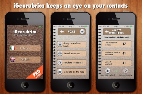
iGeorubrica - pro edition app for iPhone and iPad
Developer: Luca Alferi
First release : 26 Feb 2014
App size: 13.01 Mb
iGeorubrica is thought and realized for everyone who, because of work or something else, are continuously forced to change place and they need to be always update about the position of the contacts saved in their smartphone phonebook in order to known, in every moment, who to call, to who send a sms or an e-mail or what the shortest way is to meet them. iGeorubrica is the first app that considers the phonebook contacts as real points of interest. Through easy steps, simply moving a pin on the map, the application allows to identify the position of the contacts near to you or simulate who you could meet in a trip planning at a specific address or in a place specified not very well. iGeorubrica processes and geolocalizes your contacts without to force you to export your phonebook on a external server for the data geocodification; everything is directly done by the application in full respect of your privacy. Your data and those of your contacts are protected and safe from prying eyes. The only thing that the applicative asks to you is the possibility to accede to your phonebook data.
OPERATION
1 - Phonebook analysis
Your phonebook is read and analyzed. The contacts, for which an address has been saved, are highlighted and a geocodification for their position in the map is carried out. Waiting time is minimal and it depends on the number of the contacts saved in the phonebook and on the (in optimal conditions the result of the test was equal to 5 seconds of waiting on 1000 contacts).
2 - Look around you
This function allows to position in the map the contacts who are around you in the research range between 1 and 50 km. The application, besides to highlight the contacts in the map, lists them in a table in order of proximity. Touching every single table cell it is possible to accede to the contact detail. The detail window allows you to call, write,(an e-mail or a sms) and calculate the path (with a car or on foot) in order to reach the wanted contact. An additional opportunity that iGeorubrica offers you is the visualization of the contacts with the AUGMENTED REALITY. Entering to the iPhone camera, you can identify the contacts around you through the “clouds”. When you touch them they offer to you a general description of the contact and the distance from you. A radar shows all the found contacts for the choosen reserch range.
3 - Simulation for address
This function is particulary useful when a trip is organized. You can simulate your position at the destination address and know what and how many contacts you can meet early. The reserch range is variable between 1 and 50 Km.
4 - Simulation on the map
You can use this simulation when you want to organize a trip in a determinate place, of which you dont know the right address. Through the movement of a pin on the desired place, iGeorubrica simulates your position and filters the contacts you could meet. The simulation is carried out in a reserch range variable between 1 and 50 Km.


